Contents
Index
App Note: Directional Drilling Data
Directional Drilling is used for pipelines under road, rivers etc.
This is achieved in a relatively shallow arc or radius along a prescribed underground bore path.
Typically the data is a log of distance and depth travelled - but along the 3D trajectory.
This data can be read by GeoSurvey to create 3D points along the trajectory.
Use the Strings/Insert String Points/Insert String Pts from File option in 3D mode
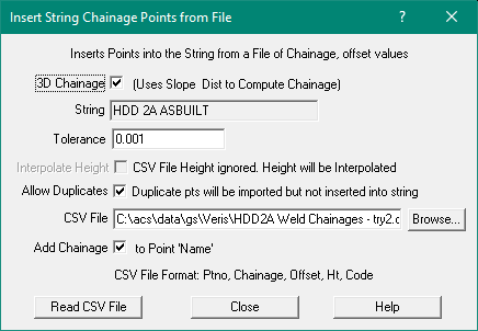
3D Chainage
When ticked, it will use Slope Distances to compute chainages.
The CSV file Chainage value will be treated as a 3D Chainage and the points inserted into the Horizontal Geometry string.
The height value for the inserted point will be interpolated from the String points.
Note: All String Points must have height values.
3D Chainages File format:
Point number - optional
Chainage - required
Offset - ignored
Height - ignored
Code - optional